
The Earth’s ionosphere is becoming more relevant to human society with its reliance on modern technology, since the accuracy of positioning and navigation, and quality of telecommunication are influenced by ionospheric weather conditions from space, Earth’s atmosphere, and lithosphere. The ionosphere significantly is a highly variable environment that exhibits significant variation with altitude, latitude, longitude, diurnal, and seasonal variation as well as solar and geomagnetic activity. This variability arises from the coupling, time delays, and feedback mechanisms that are inherent in the ionosphere-thermosphere system, as well as from the effects of the solar, interplanetary, magnetosphere, and mesosphere, stratosphere, troposphere, and even lithosphere processes. The variations of ionospheric electron density distribution can adversely affect numerous human activities and systems such as disrupting communication systems, degrading the performance of navigation and reconnaissance systems. These variations also called ionospheric climate and ionospheric weather.
The ionospheric climate, which is usually the overall feature averaged over a period of several years or decades, tells us about the normal, longer-term, and more permanent conditions of the Earth’s ionosphere. In contrast, the ionospheric weather is the short-term variations in minutes to weeks. Scientists study the ionospheric climate to look for understanding the significance of the fast-changing ionospheric weather, which critically impacts communication and navigation systems, by estimating the departure from the climate condition. Even though the ionospheric observational techniques and the ionospheric models have gone through considerable development sustained over many decades, accurate monitoring and forecasting for the ionosphere weather conditions still presents obstinate challenges. In the past decades, the ionospheric space weather is becoming more relevant to human society, with its reliance on accuracy of navigation and quality of telecommunication, which is influenced by ionospheric conditions. For that reason, a system, which used to reconstruct the electron density distribution for monitoring the variation in near real time and forecast ionospheric weather is needed in this modern society. However, unlike the meteorological weather forecast, which has been developed and operated for more than 50 years, the ionospheric weather monitoring and forecast is just starting to be developed.
Recently, based on measurements of limited ground-based receivers of the International GNSS Service (IGS), the global ionosphere map (GIM) (http://aiuws.unibe.ch/ionosphere/, CODE GIM) of the total electron content (TEC) has been routinely published for geodesy applications since 1998. The main shortcoming of the GIM is the TEC being computed from the IGS receivers on the continent. On the other hand, for military and defense applications on the instant communication, positioning, and navigation, the global assimilated ionosphere model (GAIM) is developed by the NASA/JPL and Utah State University, and is operated at U.S Air Force. However, GAIM is not open to the general public.
Six micro-satellites termed FORMOSAT-3/COSMIC (F3/C) were successfully launched into a circular low Earth orbit at 0140 UTC on 15 April 2006. Each satellite houses a GPS occultation experiment (GOX) payload for the first time deriving the radio occultation (RO) vertical profile of electron density in the ionosphere uniformly and globally (Fig. 2). By accumulating GOX observations, unprecedented detail of the three-dimensional (3D) ionospheric electron density structure can be constructed. Therefore, it is possible to follow the existing model of International Reference Ionosphere (IRI) developing an empirical model of the 3D electron density for the global ionosphere. On the other hand, the L band signal from GPS to GOX can also concurrently derive the S4 scintillation index. Liu et al. [2015] further introduce a method converting the 3D RO scintillation to the ground-based S4 index, which will benefit practical uses for communication, navigation, and positioning applications on the ground. However, the related model has not yet been developed. Following the success of F3/C, 12 small satellites of FORMOSAT-7/COSMIC-2 (F7/C2) will be launched in 2016 and 2018. This provides a much more dense coverage of the global electron density profiles [Lee et al., 2013].
The timely, uniform, and global distribution of the F3/C (also F7/C2) electron density profiles and the existing IGS TECs provide an excellent opportunity to develop a new generation integral system for monitoring, nowcast, and forecasting ionospheric weather as well as detecting temporal and spatial anomalies associated with large earthquakes. The monitoring model will be constructed by adding F3/C and F7/C2 ionospheric RO observations into the existing IGS measurements to obtain a timely and uniform GIM TEC. On the other hand, the ionospheric nowcast and forecast model will be developed by assimilating F3/C, F7/C2 and IGS observations into the model with/without including the neutral atmospheric compositions and drivers to conduct a short-term and long-term prediction, respectively. One of the most important applications and impacts of the three models are on the next generation air/automobile navigation/transportation. For example, after the ionospheric effect of the GNSS TEC is taken into account, an airplane will be able to take the optimal route and a smooth descending/ascending path. In fact, the ionospheric effect computed from the three models will also benefit GPS/GNSS navigation of automobiles. On the other hand, the S4 model can provide and predict the quality and accuracy of the satellite communication, positioning, and navigation.
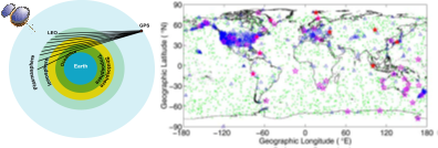
Figure 1. Left panel: The Radio Occultation technique (http://www.cosmic.ucar.edu/). Right panel: Green points stand for the distribution of daily F3/C observations, red pentagrams are locations of 10 incoherent scattering radars, opened magenta pentagrams indicate 44 available ionosondes (http://spidr.ngdc.noaa.gov/spidr/), and blue triangles refer to about 1000s IGS ground-based GPS receivers.
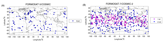
Figure 2. Distribution of observations within a 60-minute period around 300km. (A) The F3/C observations at 08:00UT on 8 April 2009 (B) The simulated F7/C2 observations which only received GPS signal only.